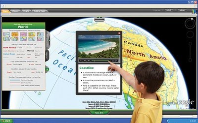
As I am early phase focused it is sometimes difficult to find ICT tools that younger learners can easily navigate through as their fine motor skills are still developing and they may not know how to read or write substantial amounts of information just yet. However, google maps would be perfect for them to use and they would really enjoy it. There are many many ways that google maps could be used in the classroom you could brainstorm all day. It could be used on an interactive whiteboard for a discussion with the whole class. I have included an image below which displays a student using google maps on an interactive whiteboard as I think it demonstrates how much of a rich resource it could really be in a classroom.
http://farm5.static.flickr.com/4065/4540299823_119b659aba.jpg
No comments:
Post a Comment